Winter Weather
[NOAA]
- Winter Weather Advisory in effect from February 21, 04:00 PM PST until February 22, 10:00 PM PST
- Freeze Watch in effect from February 23, 02:00 AM PST until February 25, 09:00 AM PST
Forecast – (900 Ft Elevation [Diamond Springs]}
Tonight
A chance of rain and snow showers early in the evening, then rain and snow showers likely in the late evening and overnight. Lows 26 to 36. Little or no snow accumulation lower elevations…up to 2 inches higher elevations. Prevailing southwest winds up to 15 mph.
Tuesday
Mostly cloudy with a chance of rain and snow showers. Highs 37 to 49. Little or no snow accumulation lower elevations… Up to 2 inches higher elevations. Snow level 2000 feet. Prevailing southwest winds up to 10 mph.
Tuesday Night
Partly cloudy. A slight chance of rain and snow showers in the evening. Colder. Lows 20 to 30. Snow level 2000 feet in the evening. Prevailing northwest winds up to 10 mph shifting to the northeast after midnight.
Wednesday
Sunny. Not as cool. Highs 42 to 54. Prevailing northeast winds up to 10 mph shifting to the northwest in the afternoon.
Wednesday Night
Clear. Lows 22 to 30. Prevailing north winds up to 10 mph shifting to the northeast after midnight.
Thursday
Sunny. Highs 46 to 56.
Thursday Night
Mostly clear. Lows 27 to 35.
Friday And Friday Night
Clear. Highs 50 to 60. Lows 27 to 39.
Saturday
Mostly sunny. Highs 56 to 64.
Saturday Night Through Sunday Night
Partly cloudy. Lows 36 to 45. Highs 58 to 66.
Monday
Mostly sunny. Highs 62 to 70
Forecast – (Pollock Pines [Elev: 4613ft.]}
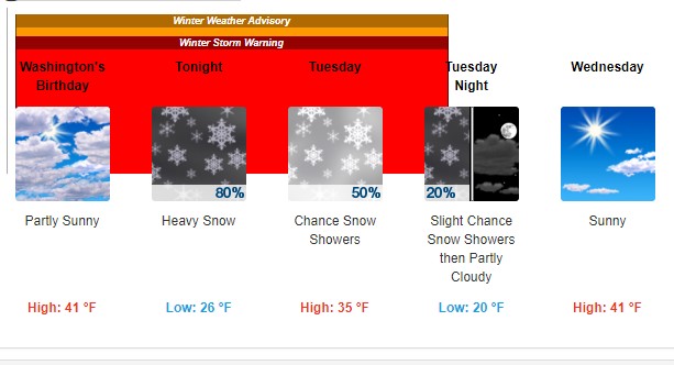
Washington’s Birthday
Partly sunny, with a high near 41. Southwest wind around 10 mph.
Tonight
Snow showers, mainly before 5am. The snow could be heavy at times. Low around 26. Southwest wind 9 to 11 mph, with gusts as high as 20 mph. Chance of precipitation is 80%. New snow accumulation of 3 to 5 inches possible.
Tuesday
A 50 percent chance of snow showers, mainly between 10am and 4pm. Mostly cloudy, with a high near 35. South wind 6 to 8 mph becoming west in the afternoon. New snow accumulation of 1 to 2 inches possible.
Tuesday Night
A 20 percent chance of snow showers before 10pm. Mostly cloudy, then gradually becoming mostly clear, with a low around 20. Calm wind becoming east around 6 mph in the evening.
Wednesday
Sunny, with a high near 41. East wind 7 to 9 mph becoming northwest in the afternoon.
Wednesday Night
Clear, with a low around 21.
Thursday
Sunny, with a high near 43.
Thursday Night
Mostly clear, with a low around 28.
Friday
Sunny, with a high near 49.
Friday Night
Mostly clear, with a low around 31.
Saturday
Sunny, with a high near 55.
Saturday Night
Partly cloudy, with a low around 37.
Sunday
Mostly sunny, with a high near 57.
Sunday Night
Partly cloudy, with a low around 38.
Monday
Sunny, with a high near 62.