Warm through mid-week in South Lake Tahoe; Cooling off some by end of the week
Submitted by paula on Sun, 05/02/2021 – 6:04pm
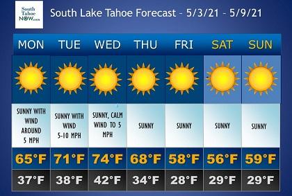
SOUTH LAKE TAHOE, Calif. – High pressure will build over the west coast with warming temperatures through mid-week. Pacific low pressure will bring increased winds Thursday and Friday along with cooler temperatures into next weekend, but precipitation chances are relatively slim, according to the National Weather Service (NWS) in Reno.
High pressure builds into the west coast Monday with afternoon high climbing back into the 70s for the lower elevations with 60s in the Sierra. Wednesday and/or Thursday appear to be the warmest day depending on the track/timing of an approaching low-pressure system for the end of the week.
Winds are likely to increase Thursday-Friday as the low enters the west coast. Be prepared for wind impacts to recreation and travel. Most gusts should stay in the 30-45 mph range with highs up near 45-55 mph in wind-prone locations.
This low will cool temperatures down and may produce a few showers for next weekend, but …
Content retrieved from: http://southtahoenow.com/story/05/02/2021/warm-through-mid-week-south-lake-tahoe-cooling-some-end-week.