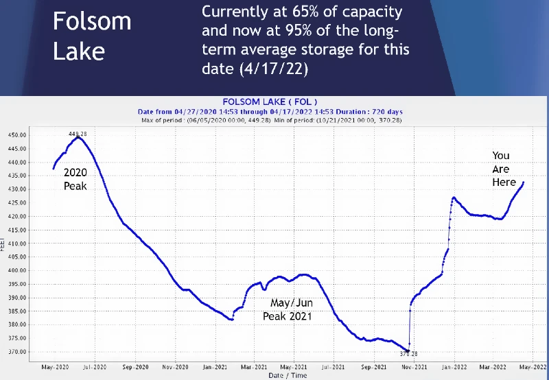
Currently at 65% of Capacity
(US National Weather)
PLACERVILLE, CA — More incoming moisture expected for the upcoming work week. Here’s a current look at Folsom Lake water storage conditions.
Cooler temps and scattered precipitation are expected to make a return this week as many California residents take to spring break.
https://www.usbr.gov/mp/cvo/vungvari/foldop.pdf
FORECAST for 4,500 Elevation
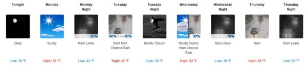
Detailed Forecast
Tonight
Clear, with a low around 39. South southwest wind around 6 mph becoming east after midnight.
Monday
Sunny, with a high near 58. South southeast wind 6 to 11 mph becoming southwest 12 to 17 mph in the afternoon. Winds could gust as high as 23 mph.
Monday Night
Rain likely, mainly after 11pm. Increasing clouds, with a low around 42. South wind 7 to 14 mph, with gusts as high as 21 mph. Chance of precipitation is 60%. New precipitation amounts between a tenth and quarter of an inch possible.
Tuesday
Rain, mainly before noon. High near 49. South southwest wind around 10 mph, with gusts as high as 21 mph. Chance of precipitation is 80%. New precipitation amounts between a half and three quarters of an inch possible.
Tuesday Night
Mostly cloudy, with a low around 38. Southwest wind 5 to 8 mph becoming light and variable in the evening.
Wednesday
A 30 percent chance of rain after noon. Mostly sunny, with a high near 52.
Wednesday Night
Rain likely. Mostly cloudy, with a low around 39. Chance of precipitation is 70%.
Thursday
Rain. Cloudy, with a high near 46.
Thursday Night
Rain likely, mainly before midnight. Mostly cloudy, with a low around 36.
Friday
A chance of rain and snow before 9am, then a chance of rain. Partly sunny, with a high near 48.
Friday Night
Areas of frost. Otherwise, partly cloudy, with a low around 36.
Saturday
Areas of frost. Otherwise, sunny, with a high near 59.
Saturday Night
Mostly clear, with a low around 40.
Sunday
Sunny, with a high near 63.