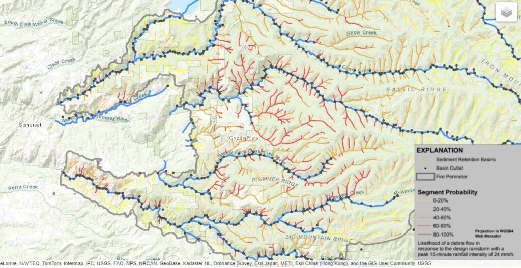
Debris Flow Risk Assessment Map
[NOAA] Detailed forecast
Mostly sunny. Warmer. Highs 57 to 65. Prevailing east winds up to 10 mph shifting to the south in the afternoon.
Mostly cloudy. A chance of rain showers after midnight. Lows 41 to 55. Prevailing southeast winds up to 15 mph.
Rain showers in the morning, then a chance of rain showers in the afternoon. Highs 51 to 65. Prevailing south winds 10 to 20 mph.
Mostly cloudy with a chance of rain showers. Lows 45 to 57. Prevailing east winds up to 10 mph.
Mostly cloudy with a chance of rain showers. Warmer. Highs 59 to 71.
Mostly cloudy with a chance of rain showers. Lows 48 to 58.
Mostly cloudy with rain likely. Highs 54 to 66.
Cloudy with a slight chance of rain. Colder. Lows 43 to 53.
Mostly cloudy with a slight chance of rain. Highs 53 to 63.
Mostly cloudy with a chance of rain. Lows 44 to 54.
Heavy rain likely. Highs 50 to 58.
Rain likely. Lows 41 to 51.
Post Fire Flood Risk
The weather forecast predicts several days of light rain followed by a heavy rain that can create a potential for flash flooding and dangerous “Debris Flow” Downstream from Fire Burned Areas.
— Preliminary Hazard Assessment —
For information on what to do if you live in a recently-burned area where debris flows are possible, and there is a rainstorm – before, during, and after, download the National Weather Service Post Wildfire Flash Flood and Debris Flow Guide (PDF 7.2 MB) at https://www.wrh.noaa.gov/lox/hydrology/files/DebrisFlowSurvivalGuide.pdf
Source Date of Origin: August 14, 2021
Eldorado National Forest, CA
Preliminary Hazard Assessment
The map depicts the likelihood of debris-flow generation and estimates of flow magnitude in locations where debris flows initiate. The models do not predict downstream impacts, potential debris-flow runout paths, and the areal extent of debris-flow or flood inundation.
The map displays estimates of the likelihood of debris flow (in %), potential volume of debris flow (in m3), and combined relative debris flow hazard. These predictions are made at the scale of the drainage basin, and at the scale of the individual stream segment. Estimates of probability, volume, and combined hazard are based upon a design storm with a peak 15-minute rainfall intensity of 24 millimeters per hour (mm/h).
Detailed Preliminary Hazard Assessment – https://landslides.usgs.gov/hazards/postfire_debrisflow/detail.php?objectid=382