CA-ENF-023040
Burned Area Emergency Response (BAER)
Assessment Report Summary
Eldorado National Forest and Lake Tahoe Basin Mgt Unit
Pacific Southwest Region
USDA Forest Service
October 2021
Fire Overview & Burned Area Description
The Caldor Fire started on August 14, 2021, about two miles east of Omo Ranch and four miles south of Grizzly Flat. The fire burned approximately 166,808 acres on the Eldorado National Forest (ENF), 9,885 acres on the Lake Tahoe Basin Management Unit (TMU), 2,076 acres on Bureau of Land Management (BLM) land, 40,183 acres of private or state lands, and in three counties (Eldorado, Alpine, and Amador)—for a total of approximately 218,952 acres–the number of acres analyzed by the BAER team as of September 18, 2021. As of October 19, 2021, the Caldor Fire burned 221,835 acres (See Figure 1).
The regional drought, combined with dry, hot weather and strong winds, resulted in very active fire behavior. Fire spread was a combination of flanking, backing, and sustained up-canyon/upslope runs. Fire spotting ahead of the head of the fire was a constant concern and threat with group torching and short duration crown fire runs. The fire spread through a combination of rapid-fire runs, long and short distance spotting, creeping and burnout operations resulting in a mosaic of fire severity on National Forest System (NFS) lands.
These dominant vegetation communities are found within the fire perimeter areas: alpine dwarf-shrub, annual non-native grassland, blue-oak/foothill pine, chamise/redshank chaparral, Jeffery pine, lodgepole pine, mixed chaparral, montane chaparral, montane hardwood/ conifer, perennial grassland, ponderosa pine, red fir, Sierran mixed conifer, subalpine conifer, wet meadow, and white fir. The Caldor burned area lies within portions of twenty-two 12-digit Hydrologic Unit Code (HUC) watersheds: Alder Creek, Bear River, Big Meadow Creek-Upper Truckee River, Camp Creek, Caples Creek, Cat Creek-Middle Fork Cosumnes River, Chimney Flat-South Fork American River, Dogtown Creek, Lake Aloha-South Fork American River, Long Canyon-Silver Fork American River, Lower-North Fork Cosumnes River, North Tragedy Creek, Plum Creek-South Fork American River, Silver Lake-Silver Fork American River, Sly Park Creek, Sopiago Creek-Middle Fork Cosumnes River, South Fork Silver Creek, Spanish Creek-Middle Fork Cosumnes River, Steely Fork Cosumnes River, Trout Creek, Upper North Fork Cosumnes River, and Upper Truckee River-Frontal Lake Tahoe (See Figure 1).
The Caldor Fire area is within the Sierra Nevada geologic province, which is characterized by granitic rocks of the Sierra Nevada. The geology is characterized by an array of rock units, generally including Paleozoic meta-sedimentary and meta-igneous rocks, Cretaceous granitics of the Sierra Nevada batholith, and Tertiary volcanics that cap ridges.
The dominant soils are derived from complex geology: within the Cosumnes River basin, the soils are primarily lava caps (lahars) capping either granitic rocks or metasedimentary marine sediments. Where the Cosumnes River has eroded canyons, the granitic and meta-sedimentary derived soils are exposed to relatively rapid erosional processes. The dominant soil textures in this area are loam soils which are prone to erosion and can generate large amounts of sediment when fire removes the protective soil cover. The soils of the South Fork American River and the Lake Tahoe Basin are dominated by glacially scraped granitic types of rock. The lahars found in the Cosumnes River basin have been removed. Those soils derived from the granitic tend to be coarse textured and do not have high erosion rates compared to the Cosumnes soils. Throughout these areas of the fire, glacial resorting and deposition result in very rocky coarse textured soils which tend to be armored from erosion.
Table 1. Miles of stream channels by order or class within the burned area
Stream Type Miles Of Stream
Canal Ditch 14
Ephemeral Stream 1,082
Intermittent Stream 300
Perennial Stream Or River 339
Pipeline 1
TOTAL 1,735
Table 2. Miles of NFS trails within the burned area
Type Miles
Snowmobile 14
Motorized 99
Non-Motorized 92
Unlabeled in GIS 3
Total – Trails 208
Table 3. Miles of NFS roads within the burned area
Maintenance Level Miles
1 – Basic Custodial Care (Closed) 286
2 – High Clearance Vehicles 463
3 – Suitable For Passenger Cars 100
4 – Moderate Degree Of User Comfort 80
5 – High Degree Of User Comfort 64
Forest Service – TOTAL 993
Non-Forest Service Roads – TOTAL 58
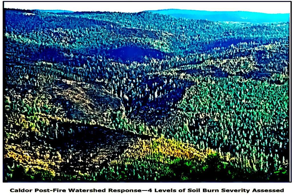
On September 8, a BAER team began assessing the western portion of the fire that had low or no fire activity. The initial team consisted of soil scientists, hydrologists and geologists focused on mapping soil burn severity levels using an initial BARC (burned area reflectance classification) satellite imagery generated map that compares pre- and post-fire images.
Additional BAER specialists, including geographic information systems (GIS) specialists, road engineers, aquatic and terrestrial biologists, archeologists, botanists, and recreation managers engaged a few days later in order to assess imminent post-fire threats to human life and safety, property, and critical natural and cultural resources.
MORE: https://inciweb.nwcg.gov/photos/CAENF/2021-09-12-2027-Caldor-PostFire-BAER/related_files/pict20210921-101423-0.pdf?fbclid=IwAR2lXMjz0ZSiWemzWGO-_lwSw1tdKpBw2Eb0Gll2Q56-5aJ18SrhGj1TFK8